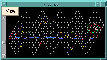
The Flat Map window shows an unfolded-PSUP view of the detector. By default, the view is from the outside of the PSUP panels, but this can be set in the View menu of this window. The x and y axis penetrations are indicated in dark green in the display. With the water level display on, the current level of light water on the PSUP is indicated in blue. The mouse can be used to grab the image and shift it horizontally and vertically. The left scrollbar controls the magnification of the image, and allows you to zoom in or out. The Move/To Home menu entry in this window is used to return to the original view.
Note that the Flat Map does not preserve area (although it isn't too far off)
because the individual faces of the PSUP geodesic have different areas but
they are mapped into equivalent equilateral triangles for this projection.